Large map of Slovakia
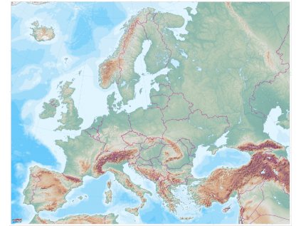
The map of Slovakia is slightly different from the other maps we have produced so far: it also includes basic geographical terms in slovakian language. When making the map, we used our previous experience in making maps, so a unique map was created that will find its place in every classroom.
All MAPUiTO tools are made by geographer and teacher Ondra based on needs children in the classroom. We make maps in Jeseníky.
We made the map based on very good experience working with the Big Map of the Czech Republic, so we decided to make a similar map for teachers in Slovakia as well.
The detailed educational map with a detailed representation of the relief is excellent for teaching, for group work around the map and as a basis for reports.
On the map of Slovakia, the largest cities, rivers, mountains and mountain ranges are marked with names. The labels are in the Slovak language.
We print the map on a plastic sheet with studs, which can withstand even the increased load of children and you can also use it for outdoor teaching.
The map is on a scale of 1:250,000 and has dimensions of 170 x 95 cm.
Detailed educational map with very detailed relief.
| Category: | e-shop |
|---|---|
| Velikost: | 170 x 95 cm |
| Materiál: | umělohmotná plachta s druky na zavěšení |
| Popisovatelná: | ne |
| Měřítko: | 1 : 250 000 |
| Lze zavěsit: | ano |
| Lze srolovat: | ano |
| Prodloužená záruka 3 roky: | ano |


When ordering a map of the Czech Republic you will receive:
Map of the Czech Republic
A describable printed map of the Czech Republic in A3 size
Why buy maps from MAPUiTO?
The maps excel in quality of display, you can see even the smallest details and underwater relief.
We produce large and durable maps that children can walk, run, work independently or in a group.
Connecting geography and learning. The maps are produced by a Montessori teacher and a physical geographer with many years of experience in geoinformatics systems.
New tools are invented together with teachers.
Lots of free supplementary materials. We create free supplementary worksheets for the maps. You can also look forward to 3D aids.
Family production for us means maximum commitment to you and attention to your requirements. We produce customized maps.
We care about the environment. Every month we plant a tree in cooperation with Arnika. We try to avoid unnecessary plastics in packaging and use paper adhesive tapes. We print all maps in the Czech Republic. We are always looking for more environmentally friendly ways to print maps and the material meets the Reach Directive.


Be the first who will post an article to this item!